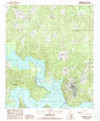
1988 Map of Farmerville
USGS Topo · Published 1988About this map
Farmerville sits as a central hub on this late-1980s landscape, positioned overlooking the expansive Bayou D'Arbonne Lake. The shoreline is heavily defined by the recreation and conservation efforts of Lake D'Arbonne State Park, which stretches along the western arms of the water. The intricate drainage network of northern Louisiana is on full display here, with numerous winding waterways such as Hunnicutt Creek, Boatwright Creek, and Fourmile Creek feeding into the main basin. On the eastern edge of the quadrangle, Bayou de Loutre meanders through the terrain. A Gaging Station and various Cem locations provide points of interest for those tracking historical infrastructure and local genealogy near the water's edge.
Find a feature on this map
17 named features on this map. Tap any name to fly to it.
Don’t see what you’re looking for? This feature index may not catch every label — zoom into the map to look around manually.
Map Details
Editions of this 1988 Farmerville Map
This is the sole edition of this map. No revisions or reprints were ever made.
Other maps of this area

1950 · Ruston
USGS Topo · 1:62,500

1951 · Ruston
USGS Topo · 1:62,500

1951 · Bernice
USGS Topo · 1:62,500

1952 · Calhoun
USGS Topo · 1:62,500

1952 · Farmerville
USGS Topo · 1:62,500

1955 · Shreveport
USGS Topo · 1:250,000

1956 · Shreveport
USGS Topo · 1:250,000
1982 · Point
USGS Topo · 1:24,000
1982 · Downsville North
USGS Topo · 1:24,000

1984 · Shreveport
USGS Topo · 1:250,000
Featured Places
- Farmerville, LA
- Eagle Point, Farmerville
- Dozier Creek, Farmerville
- Terral Island, LA
- Edgewood Circle, LA