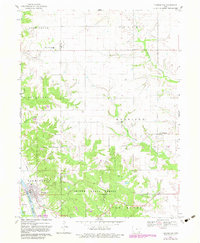
1968 Map of Farmington
USGS Topo · Published 1983About this map
Farmington sits at the southwestern edge of this landscape along the banks of the Des Moines River, serving as a primary hub for this portion of Van Buren and Lee counties. The river valley is flanked by the sprawling Shimek State Forest, which dominates the southern interior with its dense timber. This 1960s-era mapping, with later 1980s updates, captures a rural landscape where agriculture and conservation meet. Small communities like Sharon and Primrose are connected by a network of winding creeks, including Sugar Creek and Lick Creek.
Find a feature on this map
33 named features on this map. Tap any name to fly to it.
Don’t see what you’re looking for? This feature index may not catch every label — zoom into the map to look around manually.
Map Details
Editions of this 1968 Farmington Map
2 editions found
Other maps of this area

1958 · Burlington
USGS Topo · 1:250,000

1961 · Burlington
USGS Topo · 1:250,000

1963 · Burlington
USGS Topo · 1:250,000

1968 · Anson
USGS Topo · 1:24,000

1968 · Bonaparte
USGS Topo · 1:24,000
1968 · Argyle
USGS Topo · 1:24,000

1968 · Donnellson
USGS Topo · 1:24,000
1968 · Croton
USGS Topo · 1:24,000

1968 · Farmington
USGS Topo · 1:24,000
1981 · Salem
USGS Topo · 1:24,000