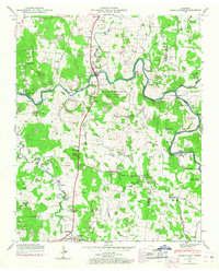
1947 Map of Farmington
USGS Topo · Published 1968About this map
The Duck River meanders across this landscape in Marshall County, carving deep bends like Powell Bluff and defining the local geography as it flows past Wilhoite Mills. This 1947 Tennessee Valley Authority survey, updated with 1960s revisions, highlights a densely settled rural network where the Louisville and Nashville railroad runs north-south through Smyrna and Farmington. The area is notably dense with family-named burial grounds and houses of worship, reflecting a deep-rooted community history anchored by sites like Bethbirei Ch and the Haskins Chapel School.
Find a feature on this map
46 named features on this map. Tap any name to fly to it.
Don’t see what you’re looking for? This feature index may not catch every label — zoom into the map to look around manually.
Map Details
Editions of this 1947 Farmington Map
4 editions found
Other maps of this area

1936 · Chapel Hill
USGS Topo · 1:24,000

1936 · Farmington
USGS Topo · 1:24,000

1936 · Rover
USGS Topo · 1:24,000

1936 · Belfast
USGS Topo · 1:24,000

1936 · Lewisburg
USGS Topo · 1:24,000

1936 · Verona
USGS Topo · 1:24,000

1936 · Rally Hill
USGS Topo · 1:24,000

1936 · Unionville
USGS Topo · 1:24,000

1936 · Bedford
USGS Topo · 1:24,000

1944 · Shelbyville
USGS Topo · 1:100,000