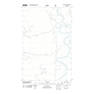
2011 Map of Farnham Peak
USGS Topo · Published 2011About this map
The Kootenai River dominates this portion of Boundary County, winding through the valley floor in large, sweeping meanders. This 2011 survey illustrates the rural character of the northern Idaho panhandle, where the settlement at Camp Five sits near the eastern edge of the quadrangle. The topography is defined by numerous drainage systems that feed into the main river channel from the surrounding highlands, including the substantial flows of Trout Creek, Ball Creek, and Farnham Creek. Transportation in the area relies on a network of forest and county roads, such as Trout Creek Rd and West Side Rd, which parallel the river and follow the contours of the lower creek valleys. The map provides a clear picture of the hydrological patterns of the region, showing how smaller tributaries like Lost Creek and Burton Creek converge as they descend toward the Kootenai.
Find a feature on this map
16 named features on this map. Tap any name to fly to it.
Don’t see what you’re looking for? This feature index may not catch every label — zoom into the map to look around manually.
Map Details
Editions of this 2011 Farnham Peak Map
This is the sole edition of this map. No revisions or reprints were ever made.
Other maps of this area

1911 · Priest Lake
USGS Topo · 1:250,000

1913 · Priest Lake
USGS Topo · 1:250,000

1958 · Sandpoint
USGS Topo · 1:250,000

1963 · Sandpoint
USGS Topo · 1:250,000

1965 · Farnham Peak
USGS Topo · 1:24,000

1965 · Moravia
USGS Topo · 1:24,000

1965 · Ritz
USGS Topo · 1:24,000

1965 · Copeland
USGS Topo · 1:24,000

1965 · Hall Mountain
USGS Topo · 1:24,000
1965 · Bonners Ferry
USGS Topo · 1:24,000