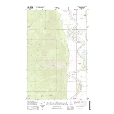
2017 Map of Farnham Peak
USGS Topo · Published 2017About this map
The Kootenai River snakes in sharp, tight oxbows through the eastern portion of this Boundary County landscape, creating a dramatic hydrological boundary against the rising slopes of the Purcell Mountains. This 2017 survey reveals the stark transition from the low-lying river valley, serviced by local routes like W Side Rd and Co Rd 18, to the high-elevation wilderness of the Kaniksu National Forest. High points such as Farnham Peak and Queen Mtn dominate the western horizon, connected by a network of drainage basins including Trout Cr and Ball Cr. The map details the complex topography of the Farnham Ridge and Russell Ridge, providing an exacting look at the forest service access roads and geographic landmarks that define this pocket of Northern Idaho.
Find a feature on this map
38 named features on this map. Tap any name to fly to it.
Don’t see what you’re looking for? This feature index may not catch every label — zoom into the map to look around manually.
Map Details
Editions of this 2017 Farnham Peak Map
This is the sole edition of this map. No revisions or reprints were ever made.
Other maps of this area

1911 · Priest Lake
USGS Topo · 1:250,000

1913 · Priest Lake
USGS Topo · 1:250,000

1958 · Sandpoint
USGS Topo · 1:250,000

1963 · Sandpoint
USGS Topo · 1:250,000

1965 · Farnham Peak
USGS Topo · 1:24,000

1965 · Moravia
USGS Topo · 1:24,000

1965 · Ritz
USGS Topo · 1:24,000

1965 · Copeland
USGS Topo · 1:24,000

1965 · Hall Mountain
USGS Topo · 1:24,000
1965 · Bonners Ferry
USGS Topo · 1:24,000