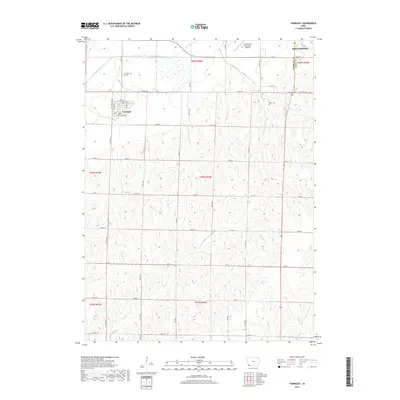
2018 Map of Farragut
USGS Topo · Published 2018About this map
The East Nishnabotna River flows through the northern reaches of this landscape, carving a wide valley across the border of Fremont and Page counties. The small community of Farragut serves as a central hub for the surrounding agricultural sections, characterized by a dense grid of rural roads and section lines. Notable for genealogists and local historians, the area includes both the Farragut Cem and the Manti Cem, marking long-standing local legacies. The northern edge of the sheet captures the southern outskirts of Shenandoah, including the Shenandoah Municipal Airport. Several tributaries, including Fisher Cr, Mill Cr, and Ledgewood Cr, drain the undulating terrain, defining the natural topography that dictated the placement of the region's homesteads and transportation routes.
Find a feature on this map
39 named features on this map. Tap any name to fly to it.
Don’t see what you’re looking for? This feature index may not catch every label — zoom into the map to look around manually.
Map Details
Editions of this 2018 Farragut Map
This is the sole edition of this map. No revisions or reprints were ever made.
Other maps of this area

1939 · Farragut
USGS Topo · 1:62,500

1939 · Hamburg
USGS Topo · 1:62,500

1940 · Farragut
USGS Topo · 1:62,500

1941 · Hamburg
USGS Topo · 1:62,500

1955 · Nebraska City
USGS Topo · 1:250,000

1957 · Nebraska City
USGS Topo · 1:250,000

1957 · Randolph
USGS Topo · 1:24,000

1958 · Nebraska City
USGS Topo · 1:250,000

1978 · Shenandoah East
USGS Topo · 1:24,000
1978 · Shenandoah West
USGS Topo · 1:24,000