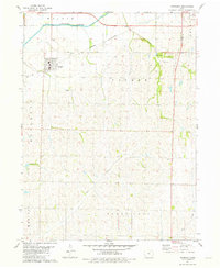
1981 Map of Farragut
USGS Topo · Published 1981About this map
Farragut serves as the primary hub of this corner of southwest Iowa, situated near the banks of the East Nishnabotna River. The landscape is defined by the drainage patterns of Fisher Creek, Mill Creek, and Ledgewood Cr, which carve through the townships of Walnut, Fisher, and Locust Grove. The Burlington Northern railroad corridor provides a clear industrial backbone for the region, while the presence of the Old Grade suggests earlier transportation routes that once serviced the agricultural community.
Find a feature on this map
20 named features on this map. Tap any name to fly to it.
Don’t see what you’re looking for? This feature index may not catch every label — zoom into the map to look around manually.
Map Details
Editions of this 1981 Farragut Map
This is the sole edition of this map. No revisions or reprints were ever made.
Other maps of this area

1939 · Farragut
USGS Topo · 1:62,500

1939 · Hamburg
USGS Topo · 1:62,500

1940 · Farragut
USGS Topo · 1:62,500

1941 · Hamburg
USGS Topo · 1:62,500

1955 · Nebraska City
USGS Topo · 1:250,000

1957 · Nebraska City
USGS Topo · 1:250,000

1957 · Randolph
USGS Topo · 1:24,000

1958 · Nebraska City
USGS Topo · 1:250,000

1978 · Shenandoah East
USGS Topo · 1:24,000
1978 · Shenandoah West
USGS Topo · 1:24,000