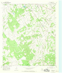
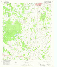
1966 Map of Farrar
USGS Topo · Published 1970About this map
The Navasota River and its intricate drainage network define this 1966 topography along the Limestone and Freestone county line. In a period of quiet rural character, the landscape is marked by small settlements like Fair Oaks, Farrar, and New Hope, which serve as the primary hubs for this agricultural and ranching region. The presence of family and community landmarks, such as Oaks Cem and Holt Cem, suggests a long-standing pattern of local settlement. While much of the land is dedicated to watercourses like Big Creek and Sanders Creek, a single Gas Well in the central portion of the sheet points to early industrial exploration in the area. The map also records several small waterways including Sassafras Branch and Pear Creek, alongside the artificial Kennedy Lake, illustrating how the local geography was adapted for resource management.
Find a feature on this map
27 named features on this map. Tap any name to fly to it.
Don’t see what you’re looking for? This feature index may not catch every label — zoom into the map to look around manually.
Map Details
Editions of this 1966 Farrar Map
2 editions found
Other maps of this area

1919 · Fairfield
USGS Topo · 1:62,500

1920 · Mexia
USGS Topo · 1:62,500

1954 · Waco
USGS Topo · 1:250,000

1955 · Waco
USGS Topo · 1:250,000

1956 · Jewett
USGS Topo · 1:62,500

1965 · Jewett
USGS Topo · 1:24,000

1965 · Dew
USGS Topo · 1:24,000
1965 · Donie
USGS Topo · 1:24,000
1966 · Round Prairie
USGS Topo · 1:24,000
1966 · Teague South
USGS Topo · 1:24,000