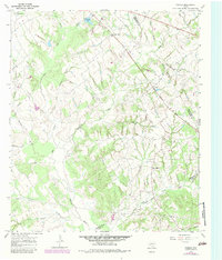
1966 Map of Farrar
USGS Topo · Published 1983About this map
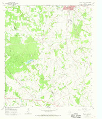
Farrar stands as the central hub of this Central Texas landscape, situated at a junction of routes between the Navasota River and the headwaters of numerous creeks. This 1966 field-checked survey reveals a quiet agricultural and early energy-producing region where the boundaries of Limestone, Freestone, and Leon Counties converge. Evidence of early settlement is preserved in the location of the Oaks Cem and Holt Cem, alongside the community at Fair Oaks. The landscape is heavily defined by its drainage network, with Sanders Creek and Big Creek carving through the terrain toward the river. Local industry and utility are marked by a Gas Well near the center of the sheet and a Mine in the southeast corner. The presence of New Hope Church and the nearby New Hope settlement indicates the importance of these rural social centers in the mid-20th century, before more modern infrastructure bypassed many of these local landmarks.
Find a feature on this map
27 named features on this map. Tap any name to fly to it.
Don’t see what you’re looking for? This feature index may not catch every label — zoom into the map to look around manually.
Map Details
Editions of this 1966 Farrar Map
2 editions found
Other maps of this area

1919 · Fairfield
USGS Topo · 1:62,500

1920 · Mexia
USGS Topo · 1:62,500

1954 · Waco
USGS Topo · 1:250,000

1955 · Waco
USGS Topo · 1:250,000

1956 · Jewett
USGS Topo · 1:62,500

1965 · Jewett
USGS Topo · 1:24,000

1965 · Dew
USGS Topo · 1:24,000
1965 · Donie
USGS Topo · 1:24,000
1966 · Round Prairie
USGS Topo · 1:24,000
1966 · Teague South
USGS Topo · 1:24,000