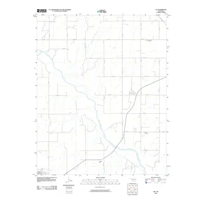
2009 Map of Fay
USGS Topo · Published 2009About this map
The Canadian River cuts a wide, meandering path through this rural Custer County landscape, shaping the local topography and settlement patterns. Established burial grounds like Mount Hope Cemetery and Liberty Cemetery serve as historical anchors for the surrounding farming community, reflecting the area's genealogical roots. The terrain is defined by a grid of rural roads, including e0830 RD and n2430 RD, which connect isolated homesteads and agricultural operations. Water management is a visible priority in this part of Oklahoma, evidenced by the presence of the Caldwell Dam and the Cowden Laterals Site 1 Dam. These structures, along with smaller tributaries like Rough Creek, highlight the essential relationship between the local workforce and the river system.
Find a feature on this map
23 named features on this map. Tap any name to fly to it.
Don’t see what you’re looking for? This feature index may not catch every label — zoom into the map to look around manually.
Map Details
Editions of this 2009 Fay Map
This is the sole edition of this map. No revisions or reprints were ever made.
Other maps of this area

1955 · Clinton
USGS Topo · 1:250,000

1957 · Clinton
USGS Topo · 1:250,000

1957 · Clinton
USGS Topo · 1:62,500

1962 · Putnam
USGS Topo · 1:62,500

1964 · Oakwood
USGS Topo · 1:62,500

1964 · Weatherford
USGS Topo · 1:62,500

1976 · Clinton NE
USGS Topo · 1:24,000
1983 · Clinton NE
USGS Topo · 1:24,000
1985 · Eagle City
USGS Topo · 1:24,000
1985 · Watonga
USGS Topo · 1:100,000