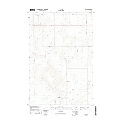
2014 Map of Fayette
USGS Topo · Published 2014About this map
Knife River and its tributary, the Little Knife River, define the undulating topography of this portion of Dunn County. The settlement of Fayette sits near the southern bend of the main river, serving as a focal point in an otherwise open landscape of section lines and gravel roads. To the north, ND-200 cuts a horizontal path across the prairie, while a grid of local routes like 116th Ave SW and 7th St SW provide access to the surrounding farmsteads. Cultural markers are concentrated at sites such as Saint Edwards Cem and the Haven of Rest Cem in the northwest, which offer valuable points of reference for genealogists tracing families in this rural corridor.
Find a feature on this map
21 named features on this map. Tap any name to fly to it.
Don’t see what you’re looking for? This feature index may not catch every label — zoom into the map to look around manually.
Map Details
Editions of this 2014 Fayette Map
This is the sole edition of this map. No revisions or reprints were ever made.
Other maps of this area

1953 · Watford City
USGS Topo · 1:250,000

1957 · Watford City
USGS Topo · 1:250,000

1963 · Hungry Man Butte
USGS Topo · 1:24,000

1967 · Watford City
USGS Topo · 1:250,000

1973 · Manning
USGS Topo · 1:24,000

1973 · Manning NW
USGS Topo · 1:24,000

1974 · Killdeer
USGS Topo · 1:100,000

1974 · Petes Creek
USGS Topo · 1:24,000

1974 · Fayette
USGS Topo · 1:24,000
1974 · Killdeer
USGS Topo · 1:24,000