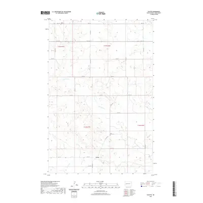
2020 Map of Fayette
USGS Topo · Published 2020About this map
The settlement of Fayette serves as the central focal point of this western North Dakota landscape, situated along the undulating drainage basins of the Little Knife River and the Knife River. This 2020 survey illustrates a sparsely populated region of Dunn County where land use is dictated by the river valleys and a rigid section-line road grid, including 10M St SW and 11TH St SW. Local heritage is anchored by quiet burial grounds such as Saint Edwards Cem in the south and Haven of Rest Cem near the northern boundary. The presence of Spring Cr in the northeast corner further defines the local hydrology, feeding into a network of small coulees that carve through the high plains. The map preserves the exact placement of these rural markers within the established boundaries of t144n r97w and neighboring townships.
Find a feature on this map
19 named features on this map. Tap any name to fly to it.
Don’t see what you’re looking for? This feature index may not catch every label — zoom into the map to look around manually.
Map Details
Editions of this 2020 Fayette Map
This is the sole edition of this map. No revisions or reprints were ever made.
Other maps of this area

1953 · Watford City
USGS Topo · 1:250,000

1957 · Watford City
USGS Topo · 1:250,000

1963 · Hungry Man Butte
USGS Topo · 1:24,000

1967 · Watford City
USGS Topo · 1:250,000

1973 · Manning
USGS Topo · 1:24,000

1973 · Manning NW
USGS Topo · 1:24,000

1974 · Killdeer
USGS Topo · 1:100,000

1974 · Petes Creek
USGS Topo · 1:24,000

1974 · Fayette
USGS Topo · 1:24,000
1974 · Killdeer
USGS Topo · 1:24,000