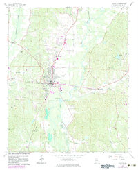
1967 Map of Fayette
USGS Topo · Published 1983About this map
The Fayette municipality serves as the central hub of this mid-century survey, situated at the confluence of the Southern Railroad and several vital waterways. The landscape is defined by the winding course of the Sipsey River and Luxapallila Creek, which frame the town's industrial and social infrastructure. Significant local landmarks such as Richard Arthur Field, the Armory, and a Drive-in Theater illustrate the community's post-war expansion and recreational development.
Find a feature on this map
44 named features on this map. Tap any name to fly to it.
Don’t see what you’re looking for? This feature index may not catch every label — zoom into the map to look around manually.
Map Details
Editions of this 1967 Fayette Map
2 editions found
Other maps of this area

1953 · Birmingham
USGS Topo · 1:250,000

1956 · Birmingham
USGS Topo · 1:250,000

1957 · Birmingham
USGS Topo · 1:250,000

1967 · Bankston
USGS Topo · 1:24,000

1967 · Winfield SE
USGS Topo · 1:24,000

1967 · Newtonville
USGS Topo · 1:24,000

1967 · Kennedy
USGS Topo · 1:24,000

1967 · Hubbertville
USGS Topo · 1:24,000

1967 · Bluff
USGS Topo · 1:24,000

1967 · Fayette
USGS Topo · 1:24,000