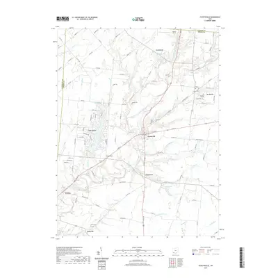
2019 Map of Fayetteville
USGS Topo · Published 2019About this map
The East Fork Little Miami River and its numerous tributaries, including Glady Run and Sattlick Cr, anchor the landscape around the village of Fayetteville. This region of northern Brown County is characterized by a high density of religious and educational landmarks, particularly in and around St. Martin, home to Chatfield College and the Ursuline Cem. The map reveals a cluster of rural settlements like Chasetown, Vera Cruz, and Ferristown, each connected by a network of state and county routes. Local history is deeply embedded in the many small burial grounds such as Vera Cruz Cem and Engle Cem, while modern developments like the private water community around Lake Lorelei contrast with the traditional farming tracts. To the north, Mackie's Airport sits near the Clinton County line, highlighting the area's mix of aviation, academia, and agrarian life.
Find a feature on this map
111 named features on this map. Tap any name to fly to it.
Don’t see what you’re looking for? This feature index may not catch every label — zoom into the map to look around manually.
Map Details
Editions of this 2019 Fayetteville Map
This is the sole edition of this map. No revisions or reprints were ever made.
Other maps of this area

1907 · Blanchester
USGS Topo · 1:62,500

1914 · Batavia
USGS Topo · 1:48,000

1914 · Morrow
USGS Topo · 1:62,500

1916 · Batavia
USGS Topo · 1:62,500

1916 · Morrow
USGS Topo · 1:62,500

1917 · Sardinia
USGS Topo · 1:62,500

1944 · Sardinia
USGS Topo · 1:62,500

1947 · Columbus
USGS Topo · 1:250,000

1953 · Newtonsville
USGS Topo · 1:24,000
1953 · Williamsburg
USGS Topo · 1:24,000