
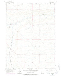
1962 Map of Federal
USGS Topo · Published 1964About this map
The small settlement of Federal serves as a focal point in this high-plains landscape, situated along the tracks of the Colorado and Southern railroad. Mapped in the early 1960s, the area is defined by its ranching heritage and the critical management of water in an arid environment. Named homesteads and operations like the Islay Ranch and King-Merritt Ranch are joined by an intricate system of irrigation features, including Chadwick Ditch No 1 and Chadwick Res No 1.
Find a feature on this map
18 named features on this map. Tap any name to fly to it.
Don’t see what you’re looking for? This feature index may not catch every label — zoom into the map to look around manually.
Map Details
Editions of this 1962 Federal Map
2 editions found
Other maps of this area

1905 · Sherman
USGS Topo · 1:125,000

1911 · Cheyenne
USGS Topo · 1:125,000

1914 · Cheyenne
USGS Topo · 1:125,000

1950 · Cheyenne
USGS Topo · 1:62,500

1954 · Cheyenne
USGS Topo · 1:250,000

1958 · Cheyenne
USGS Topo · 1:250,000

1961 · Round Top Lake
USGS Topo · 1:24,000

1961 · Cheyenne
USGS Topo · 1:62,500

1962 · Horse Creek
USGS Topo · 1:24,000

1962 · Dereemer Ranch
USGS Topo · 1:24,000