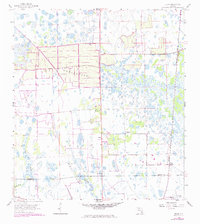
1958 Map of Felda
USGS Topo · Published 1973About this map
Twelve Mile Slough dominates the wet, low-lying landscape of Hendry County in this mid-century survey, illustrating the complex drainage patterns of the Florida interior. Small settlements like Felda and Keri serve as isolated hubs of activity along the Seaboard Coast Line railroad, which provides a vital transportation link through the wetlands. The presence of Mt Zion Ch and Felda Ch reflects the established community life in an area otherwise defined by water features such as Gator Slough and Fge Pond.
Find a feature on this map
13 named features on this map. Tap any name to fly to it.
Don’t see what you’re looking for? This feature index may not catch every label — zoom into the map to look around manually.
Map Details
Editions of this 1958 Felda Map
3 editions found
Other maps of this area

1956 · West Palm Beach
USGS Topo · 1:250,000

1957 · West Palm Beach
USGS Topo · 1:250,000

1958 · West Palm Beach
USGS Topo · 1:250,000

1958 · Felda SE
USGS Topo · 1:24,000

1958 · Immokalee
USGS Topo · 1:24,000

1958 · Felda
USGS Topo · 1:24,000

1958 · Immokalee NE
USGS Topo · 1:24,000

1958 · Felda NE
USGS Topo · 1:24,000

1958 · Alva
USGS Topo · 1:24,000

1958 · Sears
USGS Topo · 1:24,000