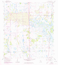
1958 Map of Felda
USGS Topo · Published 1974About this map
Twelvemile Slough dominates this landscape in Hendry County, representing the complex drainage patterns of the South Florida interior before modern development. This 1958 survey, updated in the early 1970s, captures the small settlement of Felda and its nearby namesake Felda (Station) along the Seaboard Coast Line railroad. The map shows a region defined by its water systems, including Cow Slough, Gator Slough, and the Carson Gully, which move water south toward the Hendry Co-Collier Co line. Rural life is anchored by local landmarks such as Mt Zion Ch and Felda Ch, while the northern reaches of the quadrangle feature the small hamlet of Keri. The survey provides a clear look at the area's transition between agricultural tracts and the natural marshlands typical of the region, including features like Fye Pond and an isolated Flowing Well.
Find a feature on this map
13 named features on this map. Tap any name to fly to it.
Don’t see what you’re looking for? This feature index may not catch every label — zoom into the map to look around manually.
Map Details
Editions of this 1958 Felda Map
3 editions found
Other maps of this area

1956 · West Palm Beach
USGS Topo · 1:250,000

1957 · West Palm Beach
USGS Topo · 1:250,000

1958 · West Palm Beach
USGS Topo · 1:250,000

1958 · Felda SE
USGS Topo · 1:24,000

1958 · Immokalee
USGS Topo · 1:24,000

1958 · Felda
USGS Topo · 1:24,000

1958 · Immokalee NE
USGS Topo · 1:24,000

1958 · Felda NE
USGS Topo · 1:24,000

1958 · Alva
USGS Topo · 1:24,000

1958 · Sears
USGS Topo · 1:24,000