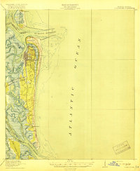
1919 Map of Fernandina
USGS Topo · Published 1919About this map
Amelia Island and its northern neighbor Cumberland Island dominate this coastal landscape at the border of Florida and Georgia. The primary settlement of Fernandina is shown with its detailed street grid and railroad connections, including the Seaboard Air Line which facilitated the region's shipping and trade. To the north, Ft Clinch stands sentinel over the St Marys Entrance, while nearby landmarks like the U S Quarantine Sta and Amelia Island L H reflect the area's importance to maritime navigation and public health in the early twentieth century.
Find a feature on this map
43 named features on this map. Tap any name to fly to it.
Don’t see what you’re looking for? This feature index may not catch every label — zoom into the map to look around manually.
Map Details
Editions of this 1919 Fernandina Map
4 editions found
Other maps of this area

1918 · St Marys
USGS Topo · 1:62,500

1918 · Cumberland Island
USGS Topo · 1:62,500

1918 · Jacksonville
USGS Topo · 1:62,500

1918 · Kingsland
USGS Topo · 1:62,500

1918 · Mayport
USGS Topo · 1:62,500

1919 · Fernandina
USGS Topo · 1:62,500

1919 · St Marys
USGS Topo · 1:62,500

1930 · Cumberland Island
USGS Topo · 1:62,500

1944 · Fernandina
USGS Topo · 1:62,500

1945 · Cumberland Island
USGS Topo · 1:62,500