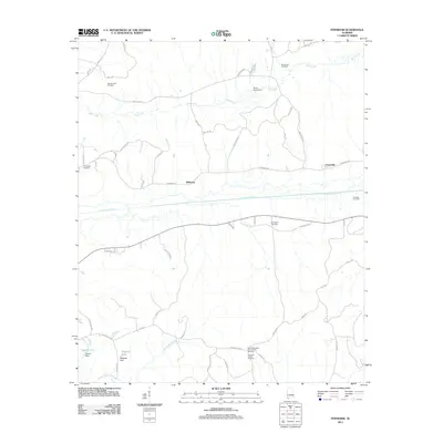
2011 Map of Fernbank
USGS Topo · Published 2011About this map
Luxapallila Creek and its complex network of tributaries define the topography of this Lamar County landscape near the Mississippi border. This 2011 survey illustrates a rural corridor where the small settlements of Melborne and Fernbank serve as local anchors. The map reveals an area where traditional agricultural and community spaces, such as Andrews Chapel and the Old Harmony Cemetery, coexist with modern industrial developments like the Mud Creek Gas Field and Fernbank Gas Field.
Find a feature on this map
56 named features on this map. Tap any name to fly to it.
Don’t see what you’re looking for? This feature index may not catch every label — zoom into the map to look around manually.
Map Details
Editions of this 2011 Fernbank Map
This is the sole edition of this map. No revisions or reprints were ever made.
Other maps of this area

1953 · West Point
USGS Topo · 1:250,000

1958 · West Point
USGS Topo · 1:250,000

1960 · Caledonia
USGS Topo · 1:62,500

1960 · Columbus
USGS Topo · 1:62,500

1963 · West Point
USGS Topo · 1:250,000

1966 · Ethelsville
USGS Topo · 1:24,000

1967 · Hightogy
USGS Topo · 1:24,000

1967 · Millport
USGS Topo · 1:24,000

1967 · Millport NW
USGS Topo · 1:24,000
1967 · Reform
USGS Topo · 1:24,000