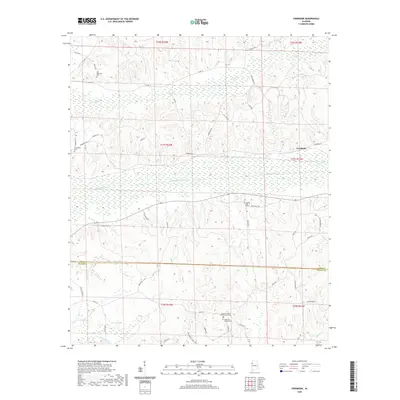
2020 Map of Fernbank
USGS Topo · Published 2020About this map
Luxapallila Creek flows westward through a landscape of gentle ridges and creek bottoms as they appeared in 2020. The rural community of Fernbank sits near the eastern edge, serving as a focal point for the surrounding homesteads and timberlands. The area is defined by a dense network of local roads such as Fernbank Rd and Co Rd 10, which connect various family-named landmarks and historical sites.
Find a feature on this map
51 named features on this map. Tap any name to fly to it.
Don’t see what you’re looking for? This feature index may not catch every label — zoom into the map to look around manually.
Map Details
Editions of this 2020 Fernbank Map
This is the sole edition of this map. No revisions or reprints were ever made.
Other maps of this area

1953 · West Point
USGS Topo · 1:250,000

1958 · West Point
USGS Topo · 1:250,000

1960 · Caledonia
USGS Topo · 1:62,500

1960 · Columbus
USGS Topo · 1:62,500

1963 · West Point
USGS Topo · 1:250,000

1966 · Ethelsville
USGS Topo · 1:24,000

1967 · Hightogy
USGS Topo · 1:24,000

1967 · Millport
USGS Topo · 1:24,000

1967 · Millport NW
USGS Topo · 1:24,000
1967 · Reform
USGS Topo · 1:24,000