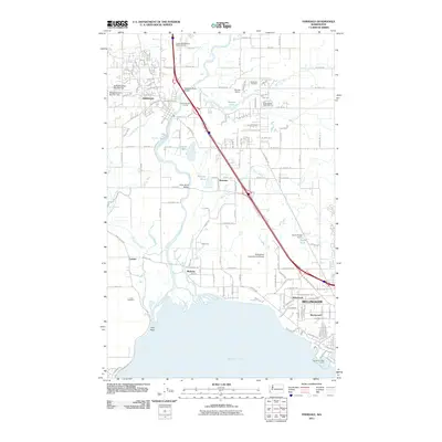
2011 Map of Ferndale
USGS Topo · Published 2011About this map
The Nooksack River winds through this coastal landscape, creating a complex network of waterways including Smuggler Slough and Slater Slough before reaching Bellingham Bay. To the north, the city of Ferndale sits as a central hub, connected by the Burlington Northern Santa Fe railroad and the prominent Nooksack River Bridge. The map details a transition from industrial and utility sites like the Ferndale Quarry and Bellingham International Airport to recreational areas such as the Riverside Golf Course. Smaller settlements like Marietta and Lummi are situated near the river's mouth, where the Lummi Cemetery and Fish Point mark the cultural and physical geography of the shoreline. The inclusion of several managed water bodies, such as Barrett Lake and Tennant Lake, alongside modern infrastructure illustrates the intensive development of this Whatcom County corridor.
Find a feature on this map
69 named features on this map. Tap any name to fly to it.
Don’t see what you’re looking for? This feature index may not catch every label — zoom into the map to look around manually.
Map Details
Editions of this 2011 Ferndale Map
This is the sole edition of this map. No revisions or reprints were ever made.
Other maps of this area

1906 · Sumas
USGS Topo · 1:62,500

1907 · Blaine
USGS Topo · 1:62,500

1908 · Sumas
USGS Topo · 1:62,500

1918 · Samish Lake
USGS Topo · 1:62,500

1943 · Anacortes
USGS Topo · 1:62,500

1951 · Anacortes
USGS Topo · 1:62,500

1952 · Bertrand Creek
USGS Topo · 1:24,000

1952 · Lynden
USGS Topo · 1:24,000

1952 · Ferndale
USGS Topo · 1:24,000

1952 · Lummi Bay
USGS Topo · 1:24,000