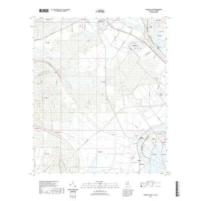
2020 Map of Ferriday South
USGS Topo · Published 2020About this map
Lake Concordia and the shifting course of the Mississippi River define this corner of Concordia Parish, where the complex hydrology of the lower Delta is visible through a network of bayous and sloughs. Just south of Ferriday, the landscape transitions from the residential streets of Ridgecrest and Saint Genevieve to the alluvial plains of Natchez Island and Cowpen Point. The map provides significant genealogical value through its documentation of small community burial sites, including Turner Acres Cem, Lambert Cem, and Saint James Cem. In the lower reaches of the quadrangle, the settlements of Willetts and Morville sit near the riverbanks, illustrating the historic reliance on the river corridor for transportation and commerce even as modern infrastructure like the Concordia Parish Airport emerged nearby. This survey preserves the intricate water systems of Turtle Bayou and Bayou Cocodrie that have long dictated the region's agricultural and settlement patterns.
Find a feature on this map
90 named features on this map. Tap any name to fly to it.
Don’t see what you’re looking for? This feature index may not catch every label — zoom into the map to look around manually.
Map Details
Editions of this 2020 Ferriday South Map
This is the sole edition of this map. No revisions or reprints were ever made.
Other maps of this area

1909 · Sycamore Landing
USGS Topo · 1:24,000

1909 · Vidalia
USGS Topo · 1:24,000

1921 · Natchez
USGS Topo · 1:48,000

1922 · Natchez
USGS Topo · 1:62,500

1939 · Red Gum
USGS Topo · 1:62,500

1939 · Natchez
USGS Topo · 1:62,500

1939 · Kingston
USGS Topo · 1:62,500

1939 · Deer Park
USGS Topo · 1:62,500

1953 · Natchez
USGS Topo · 1:250,000

1956 · Natchez
USGS Topo · 1:250,000