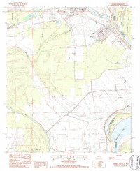
1983 Map of Ferriday South
USGS Topo · Published 1984About this map
Ferriday and the neighboring community of Ridgecrest occupy the northern reach of this Mississippi River delta landscape in the early 1980s. The region is defined by complex hydrology, where Lake Concordia and Turtle Lake sit alongside ancient oxbows and sloughs such as Hoover Slough and Campfire Slough. The heavy presence of water management infrastructure, including numerous sewage treatment ponds and a distinct canal system, reflects the challenge of development on the alluvial plain.
Find a feature on this map
41 named features on this map. Tap any name to fly to it.
Don’t see what you’re looking for? This feature index may not catch every label — zoom into the map to look around manually.
Map Details
Editions of this 1983 Ferriday South Map
This is the sole edition of this map. No revisions or reprints were ever made.
Other maps of this area

1909 · Sycamore Landing
USGS Topo · 1:24,000

1909 · Vidalia
USGS Topo · 1:24,000

1921 · Natchez
USGS Topo · 1:48,000

1922 · Natchez
USGS Topo · 1:62,500

1939 · Red Gum
USGS Topo · 1:62,500

1939 · Natchez
USGS Topo · 1:62,500

1939 · Kingston
USGS Topo · 1:62,500

1939 · Deer Park
USGS Topo · 1:62,500

1953 · Natchez
USGS Topo · 1:250,000

1956 · Natchez
USGS Topo · 1:250,000