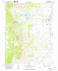
1979 Map of Ferron
USGS Topo · Published 1979About this map
Millsite Reservoir dominates the drainage of Ferron Creek, serving as a critical water source for the high desert agriculture of Emery County. This landscape reveals a complex network of 1970s hydraulic engineering, including the King Aqueduct, Independent Canal, and numerous irrigation channels like Flat Ditch and Molen Ditch that feed the fields surrounding the town of Ferron. To the west, the rugged elevations of the Manti-La Sal National Forest rise sharply, featuring prominent landmarks such as South Horn Mountain and Little Nelson Mountain. Local life is anchored in the valley by institutions like the San Rafael Sch and the County Home, while the presence of a Gas Well and several gravel pits indicates the region's diverse rural economy. Ancient paths, including the Blue Trail and various Pack Trails, continue to provide access through the steeper terrain of the forest.
Find a feature on this map
45 named features on this map. Tap any name to fly to it.
Don’t see what you’re looking for? This feature index may not catch every label — zoom into the map to look around manually.
Map Details
Editions of this 1979 Ferron Map
This is the sole edition of this map. No revisions or reprints were ever made.
Other maps of this area

1885 · Manti
USGS Topo · 1:250,000

1885 · Fish Lake
USGS Topo · 1:250,000

1895 · Manti
USGS Topo · 1:250,000

1896 · Fish Lake
USGS Topo · 1:250,000

1922 · Wasatch
USGS Topo · 1:31,680

1923 · Castle Dale
USGS Topo · 1:62,500

1925 · Castle Dale
USGS Topo · 1:62,500

1925 · Acord Lakes
USGS Topo · 1:62,500

1953 · Emery 1 NE
USGS Topo · 1:24,000

1956 · Salina
USGS Topo · 1:250,000