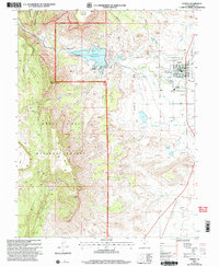
2001 Map of Ferron
USGS Topo · Published 2004About this map
The town of Ferron sits at the eastern edge of this landscape, where the plateau descent meets an intricate system of irrigation that supports local agriculture. This 2001 revision of the 1979 survey highlights the critical water infrastructure of the region, anchored by the Millsite Reservoir and the adjacent Millsite State Park. From the reservoir, a complex network including the Molen Ditch, King Ditch, and Zwahlen Ditch carves through the terrain to feed the valley floor.
Find a feature on this map
34 named features on this map. Tap any name to fly to it.
Don’t see what you’re looking for? This feature index may not catch every label — zoom into the map to look around manually.
Map Details
Editions of this 2001 Ferron Map
This is the sole edition of this map. No revisions or reprints were ever made.
Other maps of this area

1885 · Manti
USGS Topo · 1:250,000

1885 · Fish Lake
USGS Topo · 1:250,000

1895 · Manti
USGS Topo · 1:250,000

1896 · Fish Lake
USGS Topo · 1:250,000

1922 · Wasatch
USGS Topo · 1:31,680

1923 · Castle Dale
USGS Topo · 1:62,500

1925 · Castle Dale
USGS Topo · 1:62,500

1925 · Acord Lakes
USGS Topo · 1:62,500

1953 · Emery 1 NE
USGS Topo · 1:24,000

1956 · Salina
USGS Topo · 1:250,000