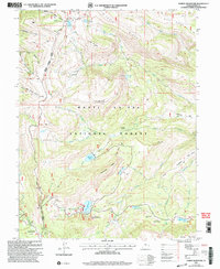
2001 Map of Ferron Reservoir
USGS Topo · Published 2004About this map
Manti - La Sal National Forest dominates this high-altitude landscape in Sanpete County, where specialized mountain infrastructure and recreation sites define the region's character at the turn of the 21st century. The map highlights the Ferron Reservoir Summer Home Area and a nearby Resort, signaling a shift toward seasonal residency and alpine tourism near the water. Higher elevations are traversed by the prominent Skyline Drive and the Western Trail, following the ridges between peaks like Cove Mountain and Lake Mountain.
Find a feature on this map
52 named features on this map. Tap any name to fly to it.
Don’t see what you’re looking for? This feature index may not catch every label — zoom into the map to look around manually.
Map Details
Editions of this 2001 Ferron Reservoir Map
This is the sole edition of this map. No revisions or reprints were ever made.
Other maps of this area

1885 · Manti
USGS Topo · 1:250,000

1895 · Manti
USGS Topo · 1:250,000

1922 · Wasatch
USGS Topo · 1:31,680

1956 · Price
USGS Topo · 1:250,000

1960 · Price
USGS Topo · 1:250,000

1962 · Price
USGS Topo · 1:250,000
1965 · Woods Lake
USGS Topo · 1:24,000

1965 · Black Mountain
USGS Topo · 1:24,000
1966 · Ferron Reservoir
USGS Topo · 1:24,000
1966 · Heliotrope Mtn
USGS Topo · 1:24,000