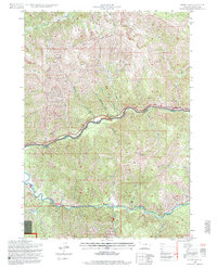
1996 Map of Ferry Peak
USGS Topo · Published 1998About this map
Snake River and Greys River converge in this high-altitude corner of Lincoln County, where the land is dominated by the overlapping boundaries of the Bridger-Teton National Forest and Grand Targhee National Forest. The geography is defined by steep drainages like Canyon Creek and Wolf Creek that feed into the major river systems. Human presence is sparse and utility-focused, centered on the Little Cottonwood Ranger Station and infrastructure such as the Squaw Creek Bridge and a Gaging Station located along the riverbanks. This 1990s revision provides a precise look at the drainage patterns of Deadhorse Basin and the secluded Little Jenny Lake, illustrating a landscape managed almost entirely for forest preservation and water monitoring.
Find a feature on this map
22 named features on this map. Tap any name to fly to it.
Don’t see what you’re looking for? This feature index may not catch every label — zoom into the map to look around manually.
Map Details
Editions of this 1996 Ferry Peak Map
2 editions found
Other maps of this area

1931 · Jackson
USGS Topo · 1:125,000

1932 · Irwin
USGS Topo · 1:96,000

1935 · Irwin
USGS Topo · 1:125,000

1935 · Jackson
USGS Topo · 1:125,000

1955 · Driggs
USGS Topo · 1:250,000

1958 · Driggs
USGS Topo · 1:250,000

1962 · Driggs
USGS Topo · 1:250,000

1963 · Munger Mountain
USGS Topo · 1:24,000

1963 · Observation Peak
USGS Topo · 1:24,000

1963 · Ferry Peak
USGS Topo · 1:24,000