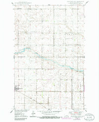
1949 Map of Fessenden East
USGS Topo · Published 1986About this map
Fessenden serves as the focal point of this North Dakota landscape, situated at the edge of a prairie terrain defined by the winding course of the James River. This 1949 survey, with revisions noted through 1986, illustrates a rural economy built around the transportation corridor of the Soo Line railroad. The map preserves the cultural geography of local townships including West Norway, Hamburg, Osh Kosh, and Germantown. These agrarian communities are anchored by landmarks like East Vang Ch, Concordia Ch, and the nearby Concordia Cem, which reflect the area's pioneer heritage and the social centers of Wells County. The topography is characterized by numerous small depressions and water features typical of the northern plains, showing the intersection of natural drainage and early mid-century settlement patterns.
Find a feature on this map
11 named features on this map. Tap any name to fly to it.
Don’t see what you’re looking for? This feature index may not catch every label — zoom into the map to look around manually.
Map Details
Editions of this 1949 Fessenden East Map
2 editions found
Other maps of this area

1932 · Flora
USGS Topo · 1:62,500

1943 · Maddock
USGS Topo · 1:62,500

1945 · Maddock
USGS Topo · 1:62,500

1948 · Cathay
USGS Topo · 1:62,500

1948 · Fessenden
USGS Topo · 1:62,500

1948 · Bremen
USGS Topo · 1:24,000

1949 · Bremen
USGS Topo · 1:24,000

1949 · Cathay
USGS Topo · 1:24,000

1949 · Fessenden SW
USGS Topo · 1:24,000

1949 · Fessenden East
USGS Topo · 1:24,000