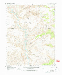
1953 Map of Fiddler Butte
USGS Topo · Published 1978About this map
The Dirty Devil River winds through a complex network of canyons and plateaus in this early 1950s survey of the Wayne and Garfield County border. The landscape is defined by massive formations such as Sams Mesa and Bert Mesa, where isolated water sources like Sams Mesa Spring and Two Pipe Springs provided essential points of interest for early travelers and ranchers. The map reveals the era's reliance on remote infrastructure, featuring several unnamed Landing Strips carved into the flat reaches of Happy Canyon and The Big Ridge. This cartography captures the area before significant modern development, emphasizing landmarks like Fiddler Butte and The Pinnacle that served as primary navigational markers in a region otherwise characterized by the intricate drainage of Hatch Canyon and Poison Spring canyon.
Find a feature on this map
41 named features on this map. Tap any name to fly to it.
Don’t see what you’re looking for? This feature index may not catch every label — zoom into the map to look around manually.
Map Details
Editions of this 1953 Fiddler Butte Map
3 editions found

Other maps of this area

1885 · San Rafael
USGS Topo · 1:250,000

1886 · Henry Mountains
USGS Topo · 1:250,000

1892 · Henry Mountains
USGS Topo · 1:250,000

1952 · Mouth of Dark Canyon
USGS Topo · 1:62,500

1952 · Orange Cliffs 3 SW
USGS Topo · 1:24,000

1952 · Mt Pennell 1 NE
USGS Topo · 1:24,000

1952 · Mt Hillers
USGS Topo · 1:62,500

1952 · Hite
USGS Topo · 1:62,500

1952 · Bull Mountain
USGS Topo · 1:62,500

1953 · Orange Cliffs 3 SE
USGS Topo · 1:24,000