
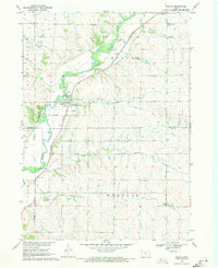
1969 Map of Fielding
USGS Topo · Published 1971About this map
The Little Sioux River meanders through this portion of Northwest Iowa, cutting a significant valley through the agrarian landscape of Cherokee and Plymouth counties. In the late 1960s, the small settlement of Fielding served as a local focal point near the convergence of numerous named drainages, including Badger Creek and Fiddle Creek. The map reveals a deeply etched topography of ridges and draws, where land use is dictated by the watercourses, such as Whisky Creek and the West Fork Fiddle Creek. Genealogical interest is found in the scattered markers of early community life, notably Trinity Cem in the north and the cluster of Mt Pleasant Ch and Mt Pleasant Cem to the east. The presence of a Gravel Pit near the southern boundary suggests the localized industrial activity supporting the area's secondary road network during this era.
Find a feature on this map
17 named features on this map. Tap any name to fly to it.
Don’t see what you’re looking for? This feature index may not catch every label — zoom into the map to look around manually.
Map Details
Editions of this 1969 Fielding Map
This is the sole edition of this map. No revisions or reprints were ever made.
Other maps of this area

1954 · Fort Dodge
USGS Topo · 1:250,000

1957 · Fort Dodge
USGS Topo · 1:250,000

1958 · Fort Dodge
USGS Topo · 1:250,000

1969 · Pierson
USGS Topo · 1:24,000

1969 · Cleghorn
USGS Topo · 1:24,000
1969 · Marcus
USGS Topo · 1:24,000
1969 · Kingsley
USGS Topo · 1:24,000
1969 · Remsen
USGS Topo · 1:24,000
1969 · Kingsley NW
USGS Topo · 1:24,000
1969 · Washta
USGS Topo · 1:24,000