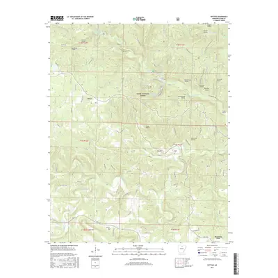
2017 Map of Fiftysix
USGS Topo · Published 2017About this map
The Ozark National Forest dominates this Arkansas landscape, where the uniquely named settlement of Fiftysix sits atop a plateau dissected by deep drainage systems. The terrain is defined by a dense network of hollows, such as Gunner Hollow, Leatherwood Hollow, and Petrie Cave Hollow, which funnel water into the N Sylamore Cr and South Sylamore Creek. Human geography is marked by small crossroads and cemeteries that anchor the community's history, including the Gayler Cem near the settlement of Gayler and the Red Doors Cem further south near Cow Mtn. The map reveals a transition toward recreation with the inclusion of the Syllamo Bike Trail-Scrappy Mt and the Mirror Lake Trail near Blanchard Spring, while older transport routes like Roasting Ear Rd follow the natural contours of the winding creek beds.
Find a feature on this map
97 named features on this map. Tap any name to fly to it.
Don’t see what you’re looking for? This feature index may not catch every label — zoom into the map to look around manually.
Map Details
Editions of this 2017 Fiftysix Map
This is the sole edition of this map. No revisions or reprints were ever made.
Other maps of this area

1890 · Mountain Home
USGS Topo · 1:125,000

1891 · Mountain Home
USGS Topo · 1:125,000

1892 · Mountain View
USGS Topo · 1:125,000

1894 · Mountain View
USGS Topo · 1:125,000

1894 · Mountain Home
USGS Topo · 1:125,000

1945 · Harrison
USGS Topo · 1:250,000

1949 · Harrison
USGS Topo · 1:250,000

1954 · Harrison
USGS Topo · 1:250,000

1956 · Russellville
USGS Topo · 1:250,000

1958 · Harrison
USGS Topo · 1:250,000