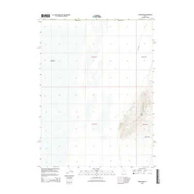
2014 Map of Finger Ridge
USGS Topo · Published 2014About this map
The Great Salt Lake Desert dominates the western half of this 2014 survey, showcasing the stark, flat hydrology characteristic of the Tooele County basins. In contrast to the expansive salt flats, the eastern margin rises sharply into the high ground of Finger Ridge, where topographic contours reveal steep, complex drainage patterns. Below these heights lies Ripple Valley, a transitional landscape between the mountain slopes and the desert floor. The only significant corridor for travel through this isolated terrain is Eagle Range Rd, which skirts the eastern foothills. This sheet provides a detailed look at the interface between the arid basin and the upland features within the Public Land Survey System grids of t3n r12w, t3n r11w, t2n r12w, and t2n r11w.
Find a feature on this map
9 named features on this map. Tap any name to fly to it.
Don’t see what you’re looking for? This feature index may not catch every label — zoom into the map to look around manually.
Map Details
Editions of this 2014 Finger Ridge Map
This is the sole edition of this map. No revisions or reprints were ever made.
Other maps of this area

1953 · Tooele
USGS Topo · 1:250,000

1954 · Brigham City
USGS Topo · 1:250,000

1955 · Tooele
USGS Topo · 1:250,000

1958 · Brigham City
USGS Topo · 1:250,000

1962 · Brigham City
USGS Topo · 1:250,000

1973 · Ripple Valley
USGS Topo · 1:24,000

1973 · Grassy Mountains
USGS Topo · 1:24,000

1973 · Knolls 2 NE
USGS Topo · 1:24,000

1973 · Grayback Hills
USGS Topo · 1:24,000

1973 · Finger Ridge
USGS Topo · 1:24,000