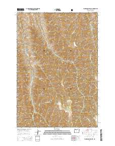
2014 Map of Fingerboard Saddle
USGS Topo · Published 2014About this map
Wallowa National Forest land defines this landscape in northeastern Oregon, where the terrain is marked by steep ridges and deep drainage gulches. High points such as Square Mtn and Kernan Point dominate the horizon, while the eponymous Fingerboard Saddle sits between the headwaters of Fingerboard Gulch and W-Fork Deep Cr. The presence of Mormon Flat, Mormon Spring, and Dad Spring suggests a history of grazing or early settlement tucked into the higher elevations. This 2014 survey reveals a network of canyons including Roy Canyon and Rowley Gulch, showing how water from sources like Lightning Cr and Butcherknife Cr has shaped the rugged geography of the region. The map provides a clear view of the complex topography along Summit Ridge and Haas Ridge, valuable for understanding the drainage patterns and land use within these forest boundaries.
Find a feature on this map
31 named features on this map. Tap any name to fly to it.
Don’t see what you’re looking for? This feature index may not catch every label — zoom into the map to look around manually.
Map Details
Editions of this 2014 Fingerboard Saddle Map
This is the sole edition of this map. No revisions or reprints were ever made.
Other maps of this area

1954 · Imnaha
USGS Topo · 1:62,500

1954 · Kernan Point
USGS Topo · 1:62,500

1955 · Grangeville
USGS Topo · 1:250,000

1959 · Grangeville
USGS Topo · 1:250,000

1963 · Cactus Mtn
USGS Topo · 1:24,000

1963 · Deadhorse Ridge
USGS Topo · 1:24,000

1963 · Wolf Creek
USGS Topo · 1:24,000

1980 · Grangeville
USGS Topo · 1:100,000

1990 · Imnaha
USGS Topo · 1:24,000
1990 · Sleepy Ridge
USGS Topo · 1:24,000