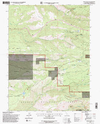
1995 Map of Finley Butte
USGS Topo · Published 1998About this map
Lyman Springs and the surrounding foothill country of Tehama County are captured in this mid-1990s U.S. Forest Service and USGS collaboration. The landscape is defined by the transition from private ranchlands like Wilson Ranch and Marian Place to the protected corridors of the Lassen National Forest and Tehama State Wildlife Area. This period shows a mix of recreational and residential land use, from the Paynes Creek Rod & Gun Club to the rural development at Ponderosa Sky Ranch.
Find a feature on this map
36 named features on this map. Tap any name to fly to it.
Don’t see what you’re looking for? This feature index may not catch every label — zoom into the map to look around manually.
Map Details
Editions of this 1995 Finley Butte Map
2 editions found
Other maps of this area

1886 · Lassen Peak
USGS Topo · 1:250,000

1892 · Lassen Peak
USGS Topo · 1:250,000

1894 · Lassen Peak
USGS Topo · 1:250,000

1935 · Paynes Creek
USGS Topo · 1:96,000

1941 · Mineral
USGS Topo · 1:125,000
1953 · Panther Spring
USGS Topo · 1:62,500

1955 · Westwood
USGS Topo · 1:250,000

1956 · Lassen Peak
USGS Topo · 1:62,500

1956 · Manton
USGS Topo · 1:62,500

1958 · Westwood
USGS Topo · 1:250,000