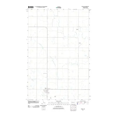
2011 Map of Finley
USGS Topo · Published 2011About this map
Finley serves as the primary hub in this portion of Steele County, its street grid organized around Main St and Broadway north of the Finley Airport. The surrounding landscape is defined by the winding course of the Middle Branch Goose River and Beaver Creek, which cut through the agricultural prairie. For those tracing family histories in the region, the map identifies three distinct burial sites: Westfield Cemetery in the northeast, Gilbertson Cemetery further south, and Ebenezer Cemetery located northwest of the town center. The rural transport network relies on a series of numbered roads, including County Hwy-16 and County Rd-4, which link isolated farmsteads to the central settlement and its local aviation facilities.
Find a feature on this map
19 named features on this map. Tap any name to fly to it.
Don’t see what you’re looking for? This feature index may not catch every label — zoom into the map to look around manually.
Map Details
Editions of this 2011 Finley Map
This is the sole edition of this map. No revisions or reprints were ever made.
Other maps of this area

1952 · Grand Forks
USGS Topo · 1:250,000

1956 · Grand Forks
USGS Topo · 1:250,000

1966 · Grand Forks
USGS Topo · 1:250,000

1967 · Finley NE
USGS Topo · 1:24,000

1967 · Blabon
USGS Topo · 1:24,000

1967 · Finley
USGS Topo · 1:24,000
1967 · Sharon
USGS Topo · 1:24,000
1967 · Aneta
USGS Topo · 1:24,000
1967 · Luverne NW
USGS Topo · 1:24,000

1968 · Sherbrooke
USGS Topo · 1:24,000