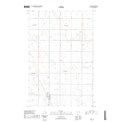
2020 Map of Finley
USGS Topo · Published 2020About this map
Finley serves as the focal point of this Eastern North Dakota landscape, situated at the junction of Co HWY 18 and Co HWY 16. The town's significance as a local center is underscored by the Steele County Courthouse, located just north of the grid-patterned streets of Main Ave and Lincoln Ave. The surrounding prairie is defined by a dense network of sectional roads and the meandering paths of the Middle Br Goose River and Beaver Cr. This 2020 survey reveals a high concentration of pioneer-era burial grounds scattered across the townships, including Westfield Cem, Gilbertson Cem, Ostervold Cem, and Ebenezer Cem. These sites, often located at distance from the primary settlement, offer critical data for genealogists tracing family roots in this rural agricultural region.
Find a feature on this map
26 named features on this map. Tap any name to fly to it.
Don’t see what you’re looking for? This feature index may not catch every label — zoom into the map to look around manually.
Map Details
Editions of this 2020 Finley Map
This is the sole edition of this map. No revisions or reprints were ever made.
Other maps of this area

1952 · Grand Forks
USGS Topo · 1:250,000

1956 · Grand Forks
USGS Topo · 1:250,000

1966 · Grand Forks
USGS Topo · 1:250,000

1967 · Finley NE
USGS Topo · 1:24,000

1967 · Blabon
USGS Topo · 1:24,000

1967 · Finley
USGS Topo · 1:24,000
1967 · Sharon
USGS Topo · 1:24,000
1967 · Aneta
USGS Topo · 1:24,000
1967 · Luverne NW
USGS Topo · 1:24,000

1968 · Sherbrooke
USGS Topo · 1:24,000