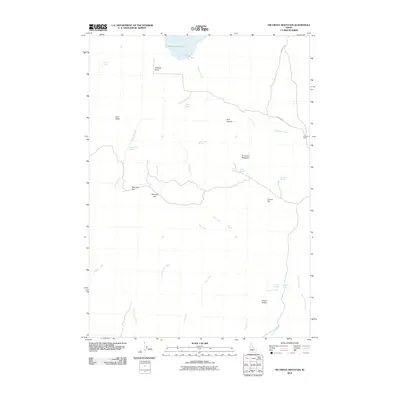
2010 Map of Fir Grove Mountain
USGS Topo · Published 2010About this map
Fir Grove Mountain dominates this portion of Gooding County, serving as a high-elevation landmark in a landscape defined by seasonal drainages and essential water sources. The 2010 survey highlights the sparse but vital human footprint at Fir Grove Ranch, accessed by the arterial Fir Grove Rd. This high desert terrain is punctuated by numerous named springs, including Cow Heaven Spring, Radarmacher Spring, and Big Mike Spring, which historically dictated the movement of livestock and travelers through the area.
Find a feature on this map
27 named features on this map. Tap any name to fly to it.
Don’t see what you’re looking for? This feature index may not catch every label — zoom into the map to look around manually.
Map Details
Editions of this 2010 Fir Grove Mountain Map
This is the sole edition of this map. No revisions or reprints were ever made.
Other maps of this area

1955 · Hailey
USGS Topo · 1:250,000

1957 · Fairfield
USGS Topo · 1:62,500

1957 · Thorn Creek SW
USGS Topo · 1:24,000

1957 · Thorn Creek
USGS Topo · 1:62,500

1957 · Davis Mountain
USGS Topo · 1:62,500

1957 · Blaine
USGS Topo · 1:62,500

1959 · Hailey
USGS Topo · 1:250,000

1962 · Hailey
USGS Topo · 1:250,000
1986 · Fir Grove Mountain
USGS Topo · 1:24,000
1986 · Mc Kinney Butte
USGS Topo · 1:24,000