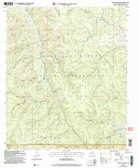
2004 Map of Firman Canyon
USGS Topo · Published 2006About this map
Mescalero Apache Indian Reservation land and the Lincoln National Forest meet in this 2004 revision of the Otero County landscape. The terrain is defined by a dense network of high-elevation canyons and vital water sources, including the central artery of Tularosa Creek and its South Fork Tularosa Canyon. Notable landmarks such as Shields Dam and the Red Cabin provide specific points of interest for local historians, while the map records numerous named water features essential for life in this arid environment, from the Head Springs in the north to Silver Springs and Turkey Pen Spring in the south. The area is crisscrossed by established forest routes, including Route 10 and Route 47, which connect the various drainages and springs like Firman Spring and Cienega Spring. This survey illustrates the intricate drainage patterns and remote outposts within the reservation boundaries prior to mid-2000s changes.
Find a feature on this map
50 named features on this map. Tap any name to fly to it.
Don’t see what you’re looking for? This feature index may not catch every label — zoom into the map to look around manually.
Map Details
Editions of this 2004 Firman Canyon Map
This is the sole edition of this map. No revisions or reprints were ever made.
Other maps of this area

1950 · Alamogordo
USGS Topo · 1:62,500

1950 · Mescalero
USGS Topo · 1:62,500

1952 · Cloudcroft
USGS Topo · 1:62,500

1954 · Carlsbad
USGS Topo · 1:250,000

1955 · Roswell
USGS Topo · 1:250,000

1958 · Carlsbad
USGS Topo · 1:250,000

1958 · Roswell
USGS Topo · 1:250,000

1962 · Roswell
USGS Topo · 1:250,000

1963 · Firman Canyon
USGS Topo · 1:24,000

1963 · Apache Summit
USGS Topo · 1:24,000