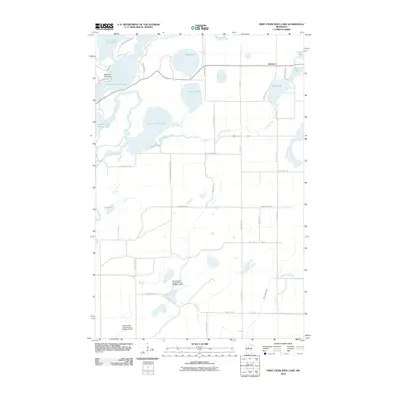
2010 Map of First Crow Wing Lake
USGS Topo · Published 2010About this map
Badoura and the surrounding Hubbard County wetlands are defined by an intricate network of waterways at the headwaters of the Crow Wing River. This 2010 survey details the transition from the upper chain of lakes, including Fourth Crow Wing Lake and Third Crow Wing Lake, into the more expansive waters of First Crow Wing Lake. The landscape is shaped by water management infrastructure, including the Washburn Lake Dam and several impoundments such as the Huntersville Impoundment Number 4 Dam. These features, along with many smaller bodies like Wolf Lake and Bladder Lake, reflect a terrain where drainage and water levels are carefully maintained. The local road system, including Huntersville Short Cut Rd and Hubbard Line Rd, provides a grid that navigates around the numerous swamps and creeks like Wallingford Creek and Bender Creek.
Find a feature on this map
43 named features on this map. Tap any name to fly to it.
Don’t see what you’re looking for? This feature index may not catch every label — zoom into the map to look around manually.
Map Details
Editions of this 2010 First Crow Wing Lake Map
This is the sole edition of this map. No revisions or reprints were ever made.
Other maps of this area

1919 · Leader
USGS Topo · 1:62,500

1953 · Brainerd
USGS Topo · 1:250,000

1957 · Brainerd
USGS Topo · 1:250,000

1958 · Brainerd
USGS Topo · 1:250,000

1965 · Brainerd
USGS Topo · 1:250,000
1969 · Nimrod
USGS Topo · 1:24,000

1969 · Burgen Lake
USGS Topo · 1:24,000

1970 · Spider Lake
USGS Topo · 1:24,000

1970 · Nevis
USGS Topo · 1:24,000

1970 · Dorset
USGS Topo · 1:24,000