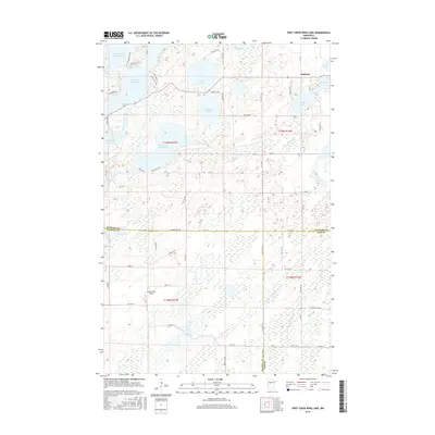
2016 Map of First Crow Wing Lake
USGS Topo · Published 2016About this map
Badoura and the surrounding lake country of northern Minnesota are defined by an intricate network of waterways and wetlands. The upper reach of the Crow Wing River connects a chain of prominent basins, including First Crow Wing Lake, Second Crow Wing Lake, Third Crow Wing Lake, and Fourth Crow Wing Lake. These glacial lakes, alongside others like Wolf Lake and Bladder Lake, reflect the post-glacial topography where land and water are tightly interwoven. To the south, the landscape transitions into more expansive marshlands, marked by Big Swamp Cr and Huntersville Field. The settlement pattern is characterized by modern rural development along routes like Co HWY 18 and Hubbard Line RD, with local landmarks like Nagel Lake and Tripp Lake illustrating the region's long-standing appeal for recreational and residential use in the heart of Hubbard County.
Find a feature on this map
46 named features on this map. Tap any name to fly to it.
Don’t see what you’re looking for? This feature index may not catch every label — zoom into the map to look around manually.
Map Details
Editions of this 2016 First Crow Wing Lake Map
This is the sole edition of this map. No revisions or reprints were ever made.
Other maps of this area

1919 · Leader
USGS Topo · 1:62,500

1953 · Brainerd
USGS Topo · 1:250,000

1957 · Brainerd
USGS Topo · 1:250,000

1958 · Brainerd
USGS Topo · 1:250,000

1965 · Brainerd
USGS Topo · 1:250,000
1969 · Nimrod
USGS Topo · 1:24,000

1969 · Burgen Lake
USGS Topo · 1:24,000

1970 · Spider Lake
USGS Topo · 1:24,000

1970 · Nevis
USGS Topo · 1:24,000

1970 · Dorset
USGS Topo · 1:24,000