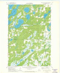
1970 Map of First Crow Wing Lake
USGS Topo · Published 1972About this map
The First Crow Wing Lake chain anchors this 1970 landscape, where the Crow Wing River connects a series of glacial basins across the Hubbard County line. The map highlights a transition between managed timberlands and recreational waters, with the northern half dominated by the Badoura State Forest and the southern reaches including portions of the Huntersville State Forest. The tiny settlement of Badoura sits near the eastern edge, while the interior is defined by complex wetlands and smaller bodies of water like Wolf Lake, Bladder Lake, and Tripp Lake. A lakeside Campground and numerous unnamed access roads suggest the area's development for outdoor use. The intricate hydrography, including Bender Creek and Wallingford Creek, illustrates the natural drainage patterns that have historically shaped this part of central Minnesota.
Find a feature on this map
19 named features on this map. Tap any name to fly to it.
Don’t see what you’re looking for? This feature index may not catch every label — zoom into the map to look around manually.
Map Details
Editions of this 1970 First Crow Wing Lake Map
This is the sole edition of this map. No revisions or reprints were ever made.
Other maps of this area

1919 · Leader
USGS Topo · 1:62,500

1953 · Brainerd
USGS Topo · 1:250,000

1957 · Brainerd
USGS Topo · 1:250,000

1958 · Brainerd
USGS Topo · 1:250,000

1965 · Brainerd
USGS Topo · 1:250,000
1969 · Nimrod
USGS Topo · 1:24,000

1969 · Burgen Lake
USGS Topo · 1:24,000

1970 · Spider Lake
USGS Topo · 1:24,000

1970 · Nevis
USGS Topo · 1:24,000

1970 · Dorset
USGS Topo · 1:24,000