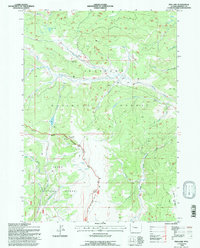
1991 Map of Fish Lake
USGS Topo · Published 1997About this map
The Continental Divide winds through this high country, serving as the defining boundary between the Shoshone National Forest and Teton National Forest. This 1991 revision, based on photography from the 1950s and late 1980s, documents a landscape shaped by hydrology and seasonal use. The presence of the Red Flat Cow Camp underscores the area's history as a grazing range, while the Lake of the Woods Trail provides evidence of the established backcountry network. Significant water features including Fish Lake and Trout Creek Lake feed a complex system of drainages such as Warm Spring Creek and Bullmoose Creek. Dominating the central topography is Fish Lake Mountain, which sits near the Ranger District Boundary, marking a transition in administrative management across this high-altitude wilderness.
Find a feature on this map
25 named features on this map. Tap any name to fly to it.
Don’t see what you’re looking for? This feature index may not catch every label — zoom into the map to look around manually.
Map Details
Editions of this 1991 Fish Lake Map
This is the sole edition of this map. No revisions or reprints were ever made.
Other maps of this area

1902 · Mt Leidy
USGS Topo · 1:125,000

1905 · Younts Peak
USGS Topo · 1:125,000

1907 · Younts Peak
USGS Topo · 1:125,000

1907 · Gros Ventre
USGS Topo · 1:125,000

1909 · Fremont Peak
USGS Topo · 1:125,000

1910 · Gros Ventre
USGS Topo · 1:125,000

1955 · Driggs
USGS Topo · 1:250,000

1955 · Thermopolis
USGS Topo · 1:250,000

1956 · Esmond Park
USGS Topo · 1:24,000

1956 · Warm Spring Mountain
USGS Topo · 1:24,000