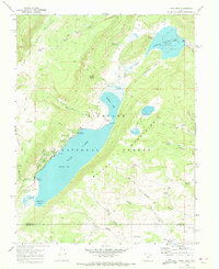
1968 Map of Fish Lake
USGS Topo · Published 1972About this map
The high alpine waters of Fish Lake and the Johnson Valley Res dominate this 1960s study of the Utah high country. Sitting at an elevation of 8843 feet, the lake is flanked by the Hightop Plateau and the Mytoge Mountains, serving as a focal point for recreation within the Fish Lake National Forest. The map documents a well-developed network of lakeside infrastructure, including the Fish Lake Ranger Sta, several dedicated camping areas such as Mackinaw Campground and Pelican Point Campground, and public Boat Ramps. The surrounding terrain is intricately detailed with seasonal drainages like Lake Creek and Tasha Creek, alongside a series of high-altitude springs including Reflection Spring and Silas Spring. This period of the forest's history is characterized by a balance of established campgrounds and primitive pack trails that lead into deep canyons like Widgeon Canyon and Pelican Canyon.
Find a feature on this map
55 named features on this map. Tap any name to fly to it.
Don’t see what you’re looking for? This feature index may not catch every label — zoom into the map to look around manually.
Map Details
Editions of this 1968 Fish Lake Map
2 editions found
Other maps of this area

1885 · Fish Lake
USGS Topo · 1:250,000

1896 · Fish Lake
USGS Topo · 1:250,000

1952 · Loa 1 NE
USGS Topo · 1:24,000

1956 · Salina
USGS Topo · 1:250,000

1960 · Salina
USGS Topo · 1:250,000

1962 · Salina
USGS Topo · 1:250,000

1967 · Lyman
USGS Topo · 1:24,000

1968 · Fish Lake
USGS Topo · 1:24,000
1968 · Hilgard Mtn
USGS Topo · 1:24,000
1968 · Boobe Hole Reservoir
USGS Topo · 1:24,000