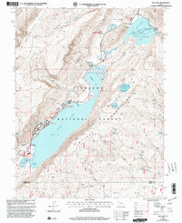
2001 Map of Fish Lake
USGS Topo · Published 2003About this map
Fish Lake dominates this high-elevation landscape within the Fish Lake National Forest, serving as a central hub for recreation and water management at the turn of the 21st century. The map illustrates a developed lakeside corridor featuring numerous established sites such as Doctor Creek Campground, Bowery Creek Campground, and Mackinaw Campground, alongside multiple boat ramps. The terrain rises sharply from the water's edge into the Mytoge Mountains and up toward the Hightop Plateau, where the hydrology of the region is traced through features like Tasha Creek and Sevenmile Cr. To the northeast, the Johnson Valley Reservoir and its Spillway manage the flow into the Fremont River, reflecting the long-standing engineering efforts to harness mountain runoff for the surrounding valleys.
Find a feature on this map
52 named features on this map. Tap any name to fly to it.
Don’t see what you’re looking for? This feature index may not catch every label — zoom into the map to look around manually.
Map Details
Editions of this 2001 Fish Lake Map
2 editions found
Other maps of this area

1885 · Fish Lake
USGS Topo · 1:250,000

1896 · Fish Lake
USGS Topo · 1:250,000

1952 · Loa 1 NE
USGS Topo · 1:24,000

1956 · Salina
USGS Topo · 1:250,000

1960 · Salina
USGS Topo · 1:250,000

1962 · Salina
USGS Topo · 1:250,000

1967 · Lyman
USGS Topo · 1:24,000

1968 · Fish Lake
USGS Topo · 1:24,000
1968 · Hilgard Mtn
USGS Topo · 1:24,000
1968 · Boobe Hole Reservoir
USGS Topo · 1:24,000