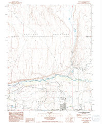
1984 Map of Fish Slough
USGS Topo · Published 1994About this map
Volcanic Table Land dominates the northern terrain of this 1980s survey, illustrating the stark transition into the Owens Valley below. The Owens River winds through the center of the sheet, constrained by the prominent Chalk Bluff to its north. This landscape is a complex network of water management and transit, featuring the South North McNally Canal and several smaller waterways like Horton Creek and McGee Creek that feed into the valley floor. To the south, the northern reaches of Bishop begin to take shape near the Bishop Paiute Indian Res and Bishop Muni Airport. The presence of numerous prospects along the eastern slopes and the small settlement at Brockmans Corner provide clear evidence of the area's dual identity as both a ranching hub and a mineral exploration zone during the late twentieth century.
Find a feature on this map
30 named features on this map. Tap any name to fly to it.
Don’t see what you’re looking for? This feature index may not catch every label — zoom into the map to look around manually.
Map Details
Editions of this 1984 Fish Slough Map
2 editions found
Other maps of this area

1912 · Mt. Goddard
USGS Topo · 1:125,000

1913 · Bishop
USGS Topo · 1:125,000

1914 · Mt. Morrison
USGS Topo · 1:125,000

1917 · White Mountain
USGS Topo · 1:125,000

1947 · Mariposa
USGS Topo · 1:250,000

1948 · Mariposa
USGS Topo · 1:250,000

1949 · Mt. Tom
USGS Topo · 1:62,500

1949 · Bishop
USGS Topo · 1:62,500

1951 · Mt. Tom
USGS Topo · 1:62,500

1951 · Bishop
USGS Topo · 1:62,500
Featured Places
- Bishop, CA
- Dixon Lane–Meadow Creek, Dixon Lane-Meadow Creek
- West Bishop, CA
- Brockmans Corner, Dixon Lane-Meadow Creek