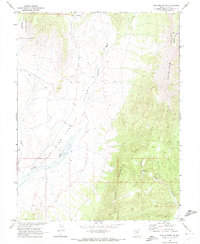
1968 Map of Fish Springs NE
USGS Topo · Published 1972About this map
Little Fish Lake Valley dominates this high-altitude terrain in Nye County, flanked by the prominent peaks of the Hot Creek Range and the Antelope Range. The map illustrates a complex drainage network where Sevenmile Wash and Savory Creek converge toward the valley floor, reflecting the arid hydrology of the Great Basin during the late 1960s. To the northwest, the boundary of the Toiyabe National Forest indicates the transition into protected public lands. Human presence is sparse, marked only by essential water infrastructure like a solitary well and a remote spring, alongside seasonal watercourses such as Moonshine Creek and Long Canyon. This survey, conducted in cooperation with the Atomic Energy Commission, provides a meticulous record of the uninhabited landscape and the Dry Valley drainage before subsequent shifts in land use or environmental change.
Find a feature on this map
13 named features on this map. Tap any name to fly to it.
Don’t see what you’re looking for? This feature index may not catch every label — zoom into the map to look around manually.
Map Details
Editions of this 1968 Fish Springs NE Map
2 editions found
Other maps of this area

1926 · Roberts Mountains
USGS Topo · 1:250,000

1929 · Roberts Mountains
USGS Topo · 1:250,000

1955 · Millett
USGS Topo · 1:250,000

1956 · Cockalorum Wash
USGS Topo · 1:62,500

1956 · Horse Heaven Mtn
USGS Topo · 1:62,500

1956 · Tonopah
USGS Topo · 1:250,000

1959 · Tonopah
USGS Topo · 1:250,000

1959 · Millett
USGS Topo · 1:250,000

1962 · Tonopah
USGS Topo · 1:250,000

1968 · Pritchards Station
USGS Topo · 1:62,500