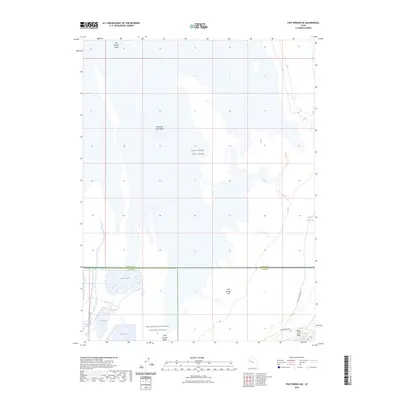
2023 Map of Fish Springs NE
USGS Topo · Published 2023About this map
Fish Springs National Wildlife Refuge occupies a critical ecological niche where the desert and wetlands meet, providing a stark contrast to the surrounding Great Salt Lake Desert. This landscape is defined by managed water features such as Gadwall Pool, Egret Pool, and Ibis Pool, which sustain life in an otherwise arid basin. The map illustrates the convergence of various land uses, from the conservation efforts at the refuge to the military presence of the West Desert Test Center. Historical transportation routes cut across the southern reaches, with the Pony Express Rd and the Lincoln Highway traversing the terrain near the Black Rock Hills. The boundary between Tooele Co and Juab Co runs horizontally through the center of these flats, marking a political division in this sparsely populated region of the West Desert.
Find a feature on this map
13 named features on this map. Tap any name to fly to it.
Don’t see what you’re looking for? This feature index may not catch every label — zoom into the map to look around manually.
Map Details
Editions of this 2023 Fish Springs NE Map
This is the sole edition of this map. No revisions or reprints were ever made.
Other maps of this area

1908 · Fish Springs
USGS Topo · 1:250,000

1910 · Fish Springs
USGS Topo · 1:250,000

1953 · Dugway Range
USGS Topo · 1:62,500

1953 · Dugway Range NW
USGS Topo · 1:24,000

1953 · Tooele
USGS Topo · 1:250,000

1953 · Delta
USGS Topo · 1:250,000

1954 · Dugway Proving Ground SW
USGS Topo · 1:24,000

1954 · Granite Peak SE
USGS Topo · 1:24,000

1955 · Tooele
USGS Topo · 1:250,000

1958 · Delta
USGS Topo · 1:250,000