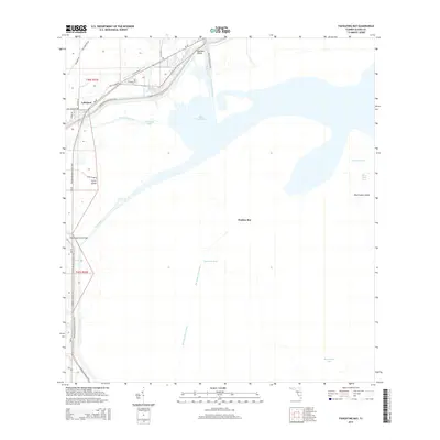
2015 Map of Fisheating Bay
USGS Topo · Published 2015About this map
Lakeport serves as a key access point on the northwestern shores of Lake Okeechobee, where the managed landscape of south Florida meets the open water. This 2015 survey illustrates a region defined by hydraulic engineering and recreational access, anchored by the massive Herbert Hoover Dyke and the Rim Canal that parallel the shoreline. The intricate network of waterways, including the Harney Pond Canal, Old Moore Haven Canal, and the natural flow of Fisheating Creek, reveals the ongoing effort to balance drainage with the preservation of the lake's ecological zones. Along the levee, the Florida National Scenic Trail provides a continuous path for hikers, passing landmarks like the Fisheating Creek Bridge. The map details the shallow shelf of the lake, naming distinctive aquatic features such as Monkey Box, Observation Shoal, and the various passes like Dynamite Pass and Whiddens Pass that navigate the marshy interior.
Find a feature on this map
32 named features on this map. Tap any name to fly to it.
Don’t see what you’re looking for? This feature index may not catch every label — zoom into the map to look around manually.
Map Details
Editions of this 2015 Fisheating Bay Map
This is the sole edition of this map. No revisions or reprints were ever made.
Other maps of this area

1953 · Brighton SW
USGS Topo · 1:24,000

1953 · Brighton SE
USGS Topo · 1:24,000

1953 · Okeechobee SW
USGS Topo · 1:24,000

1956 · West Palm Beach
USGS Topo · 1:250,000

1956 · Fort Pierce
USGS Topo · 1:250,000

1957 · West Palm Beach
USGS Topo · 1:250,000

1958 · Fort Pierce
USGS Topo · 1:250,000

1958 · West Palm Beach
USGS Topo · 1:250,000

1959 · Fort Pierce
USGS Topo · 1:250,000

1970 · Moore Haven
USGS Topo · 1:24,000