
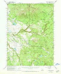
1960 Map of Fishhole Mtn
USGS Topo · Published 1962About this map
Indian Petroglyphs near the South Fork Sprague River signal a deep history of movement through this portion of the Fremont National Forest. By the mid-20th century, the landscape was defined by high-elevation ranching and forestry operations, evidenced by remote outposts like Swede Cabin, Casebeer Ranch, and the Fishhole Guard Sta. An old Railroad Grade snakes through the center of the sheet, tracing the path of former timber extraction efforts that once connected Blaisdell to the surrounding peaks. To the south, a network of water management features including Holbrook Reservoir, Lofton Reservoir, and Big Swamp Res dot the terrain near Fishhole Mtn, reflecting the essential role of water storage for this arid volcanic region. Notable landmarks like the Mitchell Monument and numerous springs like Watson Spr and Edler Spr provide specific touchpoints for local historians and genealogists researching the families who worked these allotments.
Find a feature on this map
96 named features on this map. Tap any name to fly to it.
Don’t see what you’re looking for? This feature index may not catch every label — zoom into the map to look around manually.
Map Details
Editions of this 1960 Fishhole Mtn Map
2 editions found
Other maps of this area

1889 · Klamath
USGS Topo · 1:250,000

1894 · Klamath
USGS Topo · 1:250,000

1955 · Klamath Falls
USGS Topo · 1:250,000

1958 · Klamath Falls
USGS Topo · 1:250,000

1960 · Gerber Reservoir
USGS Topo · 1:62,500

1960 · Riverbed Butte
USGS Topo · 1:62,500

1960 · Bly
USGS Topo · 1:62,500

1960 · Strawberry Butte
USGS Topo · 1:62,500

1964 · Drews Reservoir
USGS Topo · 1:24,000

1964 · Coleman Point
USGS Topo · 1:24,000