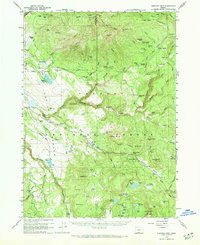
1960 Map of Fishhole Mtn
USGS Topo · Published 1972About this map
The high timberlands and volcanic peaks of Lake County are documented here during the early 1960s, a landscape defined by the upper reaches of the Sprague River and its major forks. Remote outposts like Swede Cabin and Blaisdell speak to the region's logging and ranching heritage, while various family-held properties such as the Casebeer Ranch and Owen Ranch are scattered across the flats and valleys. An extensive Old Railroad Grade meanders through the central terrain, likely a remnant of the early 20th-century timber industry that once dominated these forests. Cultural history is visible in the Indian Petroglyphs found near the South Fork Sprague River, marking indigenous presence long before the establishment of the Fishhole Guard Sta. Peaks like Gearhart Mtn and Fishhole Mtn tower over a network of springs and reservoirs, including Lofton Reservoir and Lofton Lake.
Find a feature on this map
97 named features on this map. Tap any name to fly to it.
Don’t see what you’re looking for? This feature index may not catch every label — zoom into the map to look around manually.
Map Details
Editions of this 1960 Fishhole Mtn Map
2 editions found
Other maps of this area

1889 · Klamath
USGS Topo · 1:250,000

1894 · Klamath
USGS Topo · 1:250,000

1955 · Klamath Falls
USGS Topo · 1:250,000

1958 · Klamath Falls
USGS Topo · 1:250,000

1960 · Gerber Reservoir
USGS Topo · 1:62,500

1960 · Riverbed Butte
USGS Topo · 1:62,500

1960 · Bly
USGS Topo · 1:62,500

1960 · Strawberry Butte
USGS Topo · 1:62,500

1960 · Fishhole Mtn
USGS Topo · 1:62,500

1964 · Drews Reservoir
USGS Topo · 1:24,000